
オンラインプレビューをはるかに凌ぐ、高解像度で鮮明なデジタル画像をご購入いただけます。
各ファイルは、社内の専門家が高度なツールと熟練した手作業によるレタッチを用いて、細心の注意を払って準備されています。すべての画像において、卓越した鮮明度、正確な色彩再現性、そして繊細なディテールを保証いたします。
最終ファイルは、プロフェッショナルな編集・印刷環境ですぐにご利用いただけるよう最適化された状態で、72時間以内にメールにてお届けいたします。これは、一流のデザインスタジオ、出版社、ギャラリーから信頼されているものと同等の品質です。
個人での鑑賞、印刷、クリエイティブなプロジェクト用に、高解像度ファイルをダウンロードできます。 ( プリント版に切り替え 手描きの絵画を購入)
WahooArt.com を選ぶことは、単に画像を手に入れることではありません。それは、プロの手によって精密に仕上げられ、満足保証が付いた高品質なデジタルアートワークを受け取ることを意味します。ご注文いただいた際に自動的に付随する内容は、以下の通りです:

ご注文から72時間以内に、高解像度のデジタル画像ファイルがメールでお手元に届きます。すぐにそのままご利用いただけます。

お客様の作品は、高度なAIツールと専門家による手作業の編集を組み合わせてプロフェッショナルに最適化されており、細部のディテール、鮮明さ、そして正確な色再現性を最大限に引き出しています。

ファイルを誤って削除したり、紛失してしまったりしましたか?ご安心ください。いつでも無料で再送いたします。

関税や手数料、配送料を気にすることなく、お気に入りのアートワークをすぐにお楽しみいただけます。デジタルダウンロードは常に免税です。

プロ仕様のツールとカラーマネジメント技術を用いることで、デジタル画像が元の色を最大限に忠実に再現することを保証いたします。

ご購入いただいたデジタル画像にご満足いただけない場合は、100日以内であれば、理由を問わず修正または100%の返金対応をさせていただきます。

ご満足いただけない場合は、デジタルファイルを受け取ってから100日以内であれば、理由を問わず全額返金いたします。

3枚購入で10%OFF - 5枚購入で15%OFF - 10枚以上購入で20%OFF。クリエイティブなプロジェクト、ギャラリー、エージェンシーに最適です。

Born in Lisbon around 1485, Pedro Reinel stands as a pivotal figure in the burgeoning world of Portuguese cartography during the late fifteenth and early sixteenth centuries. His life coincided with an era of unprecedented maritime exploration – the voyages of Prince Henry the Navigator, Diogo Cão’s expeditions along the African coast, and the ambitious quest to circumnavigate the globe. Reinel wasn't a flamboyant explorer himself, but rather a meticulous craftsman, a skilled mapmaker who quietly shaped European understanding of the world through his detailed charts and contributions to some of the most significant atlases of the time.
Reinel’s origins remain somewhat shrouded in mystery, though recent scholarship suggests a fascinating connection to West Africa. Historian Rafael Moreira has proposed that his father was an ivory carver brought from the region to serve within the royal workshops, bringing with him not only artistic skill but also invaluable knowledge of African coastlines and navigational techniques. This heritage undoubtedly informed Reinel’s approach to cartography, lending a unique perspective to his work – particularly evident in his remarkably detailed depictions of the African continent.
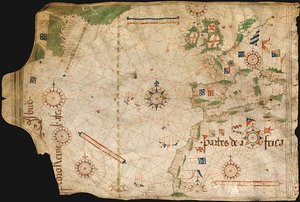
Reinel's most enduring legacy lies in his authorship of several portolan charts, those meticulously crafted nautical maps that dominated Mediterranean navigation during this period. One of the earliest and most significant examples, tentatively dated around 1485, is a testament to Reinel’s skill and dedication. This chart, now housed in the Archives départementales de la Gironde in Bordeaux, offers an extraordinary glimpse into the navigational knowledge of the time. It meticulously charts the western Mediterranean Sea, showcasing the coastline from Portugal to North Africa, and importantly, includes a remarkably detailed depiction of the African coast extending as far as the Congo River – a feat previously unseen on such maps.
What’s particularly noteworthy about this chart is Reinel's innovative approach to representing the African interior. Rather than relying solely on traditional tracing methods, he attempted to draw the continent in its true geographical form, an unusual and ambitious undertaking for the era. This demonstrates a sophisticated understanding of cartographic principles and a desire to provide his patrons with the most accurate information possible.
Reinel’s influence extended beyond individual charts; he played a crucial role in the creation of the renowned Miller Atlas (1519), a lavishly illustrated work commissioned by King Manuel I. This atlas, primarily the product of Dutch miniaturist Antonio de Holanda, showcased a remarkable blend of artistic and cartographic skill. Reinel, along with his son Jorge Reinel and the cartographer Lopo Homem, contributed significantly to the project’s design and execution, demonstrating their expertise in producing accurate and aesthetically pleasing maps.
The Miller Atlas provides valuable insight into the evolving techniques of mapmaking during this period. Notably, it represents one of the earliest instances of a scale of latitudes being incorporated onto a map – a crucial advancement that facilitated more precise navigation. Reinel’s contribution was further highlighted by his inclusion of a wind rose with a clearly defined fleur-de-lys, a detail demonstrating an awareness of prevailing winds and their influence on maritime travel.
Reinel's work also reveals a keen understanding of the complexities of navigation. He recognized that compass readings were often inaccurate due to magnetic variation – the difference between true north and magnetic north. To address this, Reinel employed two different meridians on his charts: one closely approximating true north, and another tilted approximately 22 degrees towards Labrador, accounting for the significant variations encountered by early explorers. This innovative approach reflects a sophisticated grasp of navigational challenges and demonstrates a commitment to providing sailors with the most reliable information possible.
Pedro Reinel’s contributions to Portuguese cartography were so substantial that he was honored with a Portuguese postage stamp in 1935, a testament to his enduring legacy. His work continues to be studied and appreciated by historians and map enthusiasts alike, offering a fascinating window into the intellectual and technological developments of the Age of Discovery. Reinel’s maps are not merely representations of geographical space; they are windows into the minds of those who navigated, explored, and shaped our understanding of the world.
1485 - 1542 , Portugal


 プレビュー
プレビュー
 シェアする
シェアする シェアする
シェアする
 詳細を見る
詳細を見る

 ダウンロード
 似ている作品
 X線調査
X線調査 スライドショー
 統計情報
統計情報
 詳細を見る
詳細を見る


